Monday, November 25, 2013

Mount Wrightson (AZ)


I was meeting my brother and others in Safford Friday afternoon (November 1st), so the morning gave me a suitable time window in which to trudge up another mountain, to sneak a peak, so to speak. My research led me to Mount Wrightson, a highly regarded objective an hour south of Tucson. At 9,453 feet, it’s the highest summit of the Santa Rita Mountains. With an elevation gain of just over 4,000 feet in five miles, it is also one of the more ambitious dayhikes in the region. The weather could not have been more perfect.

38. Mount Wrightson: I left the trailhead in Madera Canyon around 10:30 am, opting for the more direct Old Baldy Trail, rather than the gentler but longer Super Trail. Both converge at Josephine Saddle, where a marker denotes the tragic demise of three young boy scouts who became lost in a snowstorm near the saddle a half century ago. The trail continued up the ridge and into an upper basin with occasional views of the valley below and the peak above. Yellow crags jutted up from the forest where a series of short switchbacks brought me to the high crest north of the mountain. The final scenic spur to the top gained the last 800 feet in less than a mile, and I was on top by 2:00 pm. There I met two couples, including a mother and son repeating a hike they’d done when he was a kid. She rightly (Wrightly?) bragged that her parents had also made the trek when they were in their 70s. I wanted to stay, but alas, I had obligations in Safford that I was already running late for. There are other good hikes in the area and I will have to return at some point. But for now, I raced down the mountain, happy that my knee was still holding up well despite the abuse.
Miles (RT):  10.4 miles; elevation gain: 4,000 feet
Cumulative mileage and gain:  165.8 miles / 47,000 feet


Mount Wrightson summit.


Half way there!


Good looking charmer.

At the top, Mount Hopkins behind.

Sky island country.


Five-minute rest.

Pusch Peak (AZ)


On Halloween, I flew to Tucson where my brother and I were hosting a weekend memorial in Safford for dad, who passed away a year before. My plane arrived early enough in the day that I had just enough time for an energetic hike up Pusch Peak, a few miles north of downtown. Pusch, at just over a mile high, is the westernmost summit of the Santa Catalina Mountains. Given the distance and elevation and a 5:30 pm sunset, I calculated there was just enough time to nab the summit before dark. The weather was perfect, sunny and not quite 80 degrees.

37. Pusch Peak: I hit the trail at 2:00 pm and meandered among the prickly pear and creosote into the saguaro zone, with the rocky summit looming dead ahead. As warned, the climb was steep, but the trail was in better shape than I had imagined from the descriptions online. It was just a matter of upward trekking as the valley beneath me slowly fell away from one turn to the next. I saw no one else on the mountain, though Pusch is sure to be a popular weekend hike. I was on the splendid summit by 3:50 pm, which allowed a short rest and still the hour and a half I needed to descend before dark.
From the top, the views into the Santa Catalinas and out across Tucson and Oro Valley were fabulous. Although I was a long way from Mount Lemmon, the high point of the range, I enjoyed once again, one of those top-of-the world moments that make peakbagging a more sensible and honorable endeavor than some might presume. On the way down, the brilliant light of the pre-setting sun turned the mountain to gold and lit up the stately saguaros like little monuments. This one was going into the journal as one of the most enjoyable of the Sixty.
Miles (RT):  4.1 miles; elevation gain: 2,700 feet
Cumulative mileage and gain:  155.4 miles / 43,000 feet


Summit rock.


Out by sunset.

Strickler Knob (VA)


Kris and I joined the Center Hiking Club (October 27) for this moderate jaunt to a highly rated vista atop Massanutten Mountain. Massanutten, just west of Shenandoah National Park, is one of countless linear ridge systems forming the mid-Atlantic portion of the Appalachians. Many of the high points are rocky crags and sometimes the ridge crest itself is exposed rock offering views across the adjoining valleys. Strickler had both. Access has become easier in recent years thanks to the efforts of volunteer trail builders. One of the write-ups online warned of rattlesnakes warming themselves on the rocks. I noticed our experienced hike leader bounding up the ridge in shorts, unconcerned, which suggested that those who’ve hiked these hills for many years remain unfazed by the threat.

36. Strickler Knob: Fall colors enhanced the walk-in-the-woods portion of the hike and the scenic ridge gave a nice finish. The top was a craggy jumble of giant boulders that we scaled for more views and a quick lunch. While there were bound to be snakes lurking in the rocks, none came out to greet us.
Miles (RT):  9.5 miles; elevation gain: 1,800 feet
Cumulative mileage and gain:  151.3 miles / 40,300 feet


Strickler Knob summit.

Syracuse (NY)


About 29 years ago, give or take, Kris’s parents, Dave and Kathy, landed in Syracuse while Dave was learning Russian at the University as a member of the Air Force. Momentous things happened back then, including, of note, the birth of my wife-to-be. They were soon shipped off to Japan, however, well before the new addition to the family had developed any actual memories of the place. Kris had never gone back, and thus it was that Syracuse moved to the top of her list of places to go when we came out east. Syracuse and Niagara (below) are not so far apart, so we planned our four-day circuit to take in the best of both.

We arrived in Syracuse (October 14) fashionably after dark, which seems to be our thing when traveling. Kris navigated to the Jefferson Clinton Hotel downtown, which had some positive ratings online. It turned out to be the perfect spot and a great hub from which to explore a number of city sights. Our only regret was that we couldn’t stay another night.


A few highlights: We had a fantabulous dinner at Pastabilities—the best rigatoni I’ve ever had, wow. From there we ambled over to the Dinosaur Bar-B-Que, a regional hotspot for live music and good grub. They call themselves a “honky tonk rib joint” and the moniker fits. A perfect after-dinner spot, a cut above a dive bar. A solo guitar player, accompanied by a drumming puppet, hammered out familiar rock classics and some original items of his own.
Dinosaur BBQ after a couple glasses of wine.

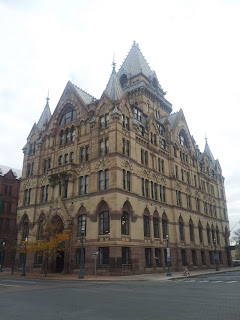
Next morning we enjoyed a complimentary omelet breakfast at the hotel, then wandered all over downtown (see photos). We worked our way toward some addresses Kris had for the apartments her parents lived in while stationed in Syracuse. One seemed to have devolved into a parking lot, but the other was still standing strong. Kris zapped a photo to her mom for confirmation. Yup, it was the place. We rambled through the university grounds and down the hill to the Erie Canal Museum, which was quite excellent. Another highlight was a large wading pool in a giant plaza where the Erie Canal once carried canal boats hundreds of miles through dozens of stone locks.
We still had a good six-hour drive ahead to get back to DC, but first made a final stop for a late lunch at Coleman’s, a famed and stylish Irish pub out in one of the neighborhoods. Then it was drive, drive, drive, and finally home in the pre-wee hours.


Language School at Syracuse University.


Skating on the Erie Canal.


Where'd my house go?

Nice digs.

Coleman's.

Note the leprechaun entrance.


On the road in Seneca Falls, NY.