Grandfather Mountain in the Black Mountains northeast of
Asheville is unusual in that its primary access is within a privately-owned
park and reserve run by the Grandfather Mountain Stewardship Foundation, although
a sizable chunk of the mountain is within a new (2008) state park. I was a
little dubious about forking over the $18 entrance fee, since the higher ground
I was interested in appeared to be over-developed. The drive
up was nice enough and a few pullouts offered great views, but I would have
preferred a little less pavement at the top. A much lower parking area with a
trail heading upward would make a nice improvement. Nevertheless, the trail
from the upper lot quickly departs the car zone and the crowds and provides for a superb hike
through Grandfather’s gorgeously rugged high country.
The elderly mountain rises to just shy of 6,000 feet and
encompasses a number of named peaks, the highest of which (Calloway) was once
thought to be the highest point east of the Mississippi. It turned out that the
highest was actually Mount Mitchell (6,684 feet), also in the Black Mountains,
but well to the south. That makes the Blacks the highest mountain range in the
eastern U.S.—certainly an area not to be missed by any self-respecting, mission-driven
peakbagger.
I was parked and on the trail by 9:30 am on October 5th. Six
hours later, back in the car zone, I'd summited four peaks along the
ridge: Linville, MacRae, Attic Window and Calloway. Linville we can debate—it
was a little too easy to go bragging about. Attic Window (who names a peak Attic
Window anyway?) was just a brief knee cruncher. But it’s October and I’ll take
what I can get.
 |
| The Wiggling Bridge. |
28. Linville Peak: From the parking lot, a 0.4-mile trail
leads upward 300 feet to the famed “Swinging Bridge,” which happens to be one
of the major draws for people headed to the mountain. The impressive 228-foot
long footbridge spans a rocky gulch and connects the upper paved-over zone to
the rocky top of Linville Peak. I scooted over and shuffled up to the high
point. The old bridge was rebuilt in 1999 and was designed to be more stout, so
it doesn’t swing so much any more. It wiggles. It’s something to marvel at just the same.
A marker in the middle notes the elevation—5,280 feet—a
vertical mile above sea level.
Miles (RT): 0.8 mile;
elevation gain: 300 feet
Cumulative mileage and gain:
126.6 miles / 35,650 feet
29. MacRae Peak: MacRae would prove to be the most enjoyable
summit of the day. Leaving the parking lot opposite the Swinging Bridge, one
immediately begins to climb steeply on rough, rocky ground to a wooded nubbin,
then down slightly to a saddle before the real fun begins—ropes, cables and
beefy ladders leading up slabs and cliffs to more fun stuff above. At a ladder, I met Pete,
a devout hiker dude from Florida taking photos with a digital SLR, which made
me wonder about relying on my smartphone so much to record my adventures. It
turned out we had much in common and hiked in tandem the rest of the day.
After a little more upness, you finally see two hefty blocks
ahead with little people perched on top. A final 20-foot ladder to another
cable handline makes the insurmountable summit surmountable. If you enjoy easy
scrambling and your acrophobia is in check, MacRae is a totally entertaining
“hike.” Kudos to those who laid out the route and have kept it maintained for
public access all these years. Not for the faint-hearted, of course, but for my
climbing friends and for more experienced hikers, it’s a walk in the park—at
least when it’s sunny and nice out. I don’t think I’d be smiling as much if I was stuck up there in
rainy, icy or electrified weather.
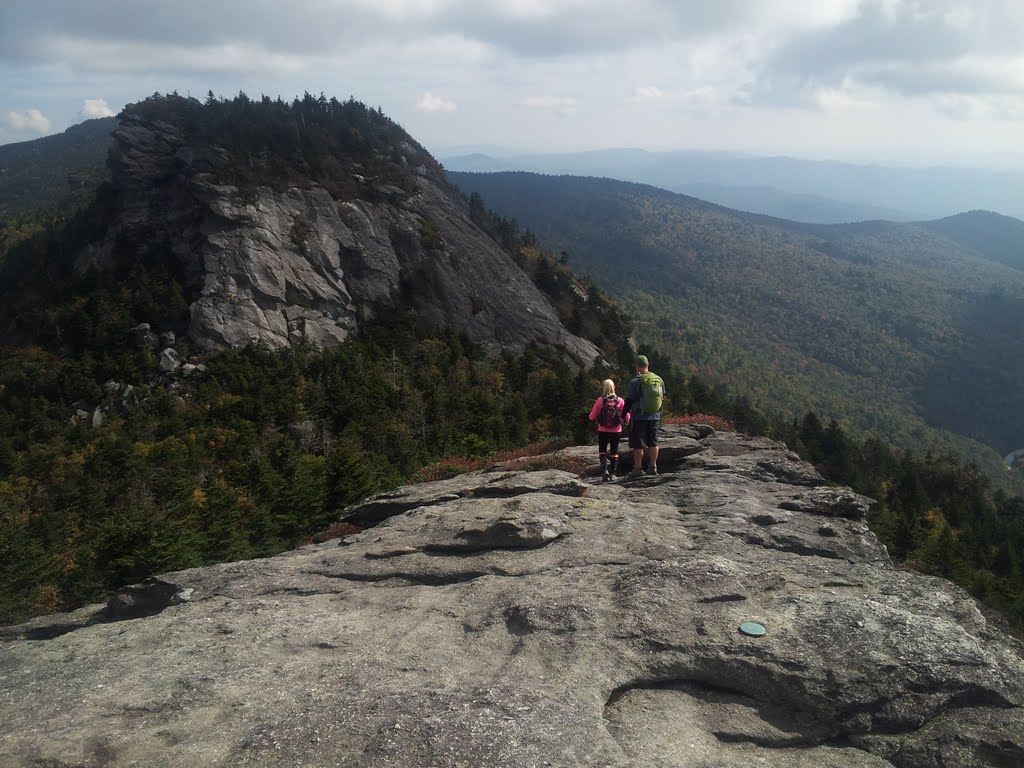
31. Calloway Peak: Just past Attic Window, at a point where
the trail runs along the edge of a precipice, we passed a young, barefoot
fellow who said he’d been on the trail many times before and wanted to
experience things a little differently this time—so he skipped his boots. I could tell by looking at his eyebrows that his feet were on fire, but kept his chin up just the same. From
there Calloway looked like it was 40 minutes away, though the signs suggested
it was not even a mile. We were on top in 20. I lingered to enjoy a
quick lunch and another stunning view, though not quite as dramatic as MacRae’s.
All in all, Grandfather Mountain gave me no regrets about
that $18 entry fee. And I got to bag four glorious summits while hardly
breaking a sweat. By the way, there is a back way in via the state park, for
those who might prefer that option, though it’s not nearly as convenient. My new pal, Pete, and I agreed we should plot a hike together in the near future, and bring the wives as well, both of whom also enjoy getting out on the trail.
 |
| Calloway Peak from near the top of Attic Window. |
 |
| Going light. |
 |
| A final obstacle. |
 |
| Looking back at Attic and McRae. |
 |
| Don't do it! |
 |
| The expedition photographer (Pete). |
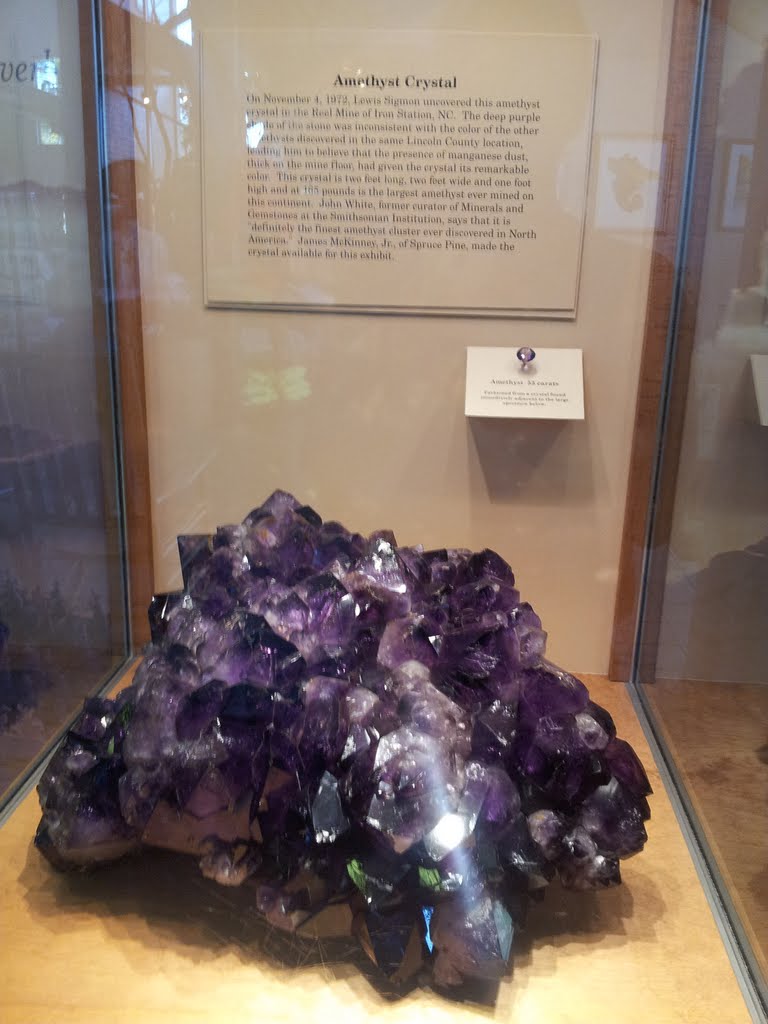
On the way down the mountain, I stopped at the Habitat area,
a veritable zoo perched on the mountainside where visitors can view black bears,
mountain lions, bald eagles and otters at close range. These are animals that were
injured or otherwise unable to survive on their own in the wild. The museum
next door is also nicely done and displays the largest amethyst crystal ever
mined in North America, as well as what’s got to be the largest wooden bowl (about the size of a hot tub) ever carved
from a burl. The dern thing is six feet across. The ice cream and homemade fudge were
also excellent. You come away feeling like the people who run Grandfather
Mountain are pretty dedicated to the place. It’s a lot to look after and they
seem to do a stellar job of it.
Miles (RT): 4.8 mile;
elevation gain: 1,500 feet (including all three peaks)
Cumulative mileage and gain:
131.4 miles / 37,150 feet
 |
| That black dot is a bear. |
 |
| The furry thing under the rock is a mountain lion. |
 |
| This is a really big amethyst. |
 |
| The monstrous burl. |